During the Civil War, military activity reached its zenith in the southwestern portion of the state in late 1863 after the United States army occupied Arkansas’s capital city. When Little Rock came under Union control in September of that year, thousands of soldiers of the Confederate States Army traveled from Little Rock through Rockport toward the southwest to escape oncoming Union troops. Arkansas’s Confederate capital was established at Washington (Hempstead County), and Governor Harris Flanagin of Arkadelphia conducted the state’s business from there.
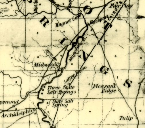
As the war wore on, troops were in and around southwest Arkansas for the duration of the great conflict. The Military Road, also often called the Southwest Trail, served as a major transportation artery and passed through the heart of Hot Spring County. Official records and documents illustrate the level of activity taking place in the region from the time of the fall of Little Rock through the spring of 1865 when the war finally came to an end. One such document, a Union officer’s report dated December 17, 1863, describes the movement of his men through Rockport and the surrounding area:
“Parsons’ brigade of rebel cavalry was camped near Princeton, with some artillery . . . I left this place with part of my command, and reached Benton that evening, being there joined by the artillery and the rest of my command. The next day I reached Rockport, on the Washita, and found that about 150 rebel cavalry, belonging to Cabell’s brigade, had left there about two hours before my arrival. Here, as elsewhere throughout the entire march, I heard all sorts of reports of the enemy, from which reports I judged that Cabell’s brigade was camped that night on Caddo Creek, 4 miles north of Arkadelphia, on the west side of the Washita; that some command was camped below Princeton, and that Price’s whole army was advancing from Camden, probably toward Little Rock or Pine Bluff.
“The Washita is subject to very sudden rise, and the sky was threatening rain. This, with the importance of finding out the truth of Price’s reported advance, determined me to make a feint toward Arkadelphia, while I moved upon the force near Princeton, and drove them far enough to determine Price’s movements.
“For several miles below Rockport the roads to Tulip and Arkadelphia are the same, and I accordingly moved my whole command toward Arkadelphia, as far as the dividing point, from which I sent the Third Iowa and First Missouri, under Major Peabody, to make a demonstration of movement toward Arkadelphia, while I marched the main body on the road to Tulip.
“About 10 o’clock I received reliable information that the command near Princeton was an outpost from Camden, about 700 strong, under the command of Colonel Crawford, and that Parsons’ brigade was not there. I pushed forward now with all possible haste, hoping to be able, by throwing a part of my troops in their rear, to cut them off and capture the whole body. About noon, however, a heavy rain began falling, and continued until daylight next morning. This made the roads so heavy that I could not keep the artillery up without entirely wearing it out, and entirely frustrating the plan proposed, as it would make the night too dark to move troops across the country with success. I accordingly went into camp at Tulip, which I reached just at dark.”