The United States’ Louisiana Purchase in 1803 spurred American settlement of land west of the Mississippi River, including the Ouachita River valley. Upon arrival, new residents cleared land and began to till the soil close to creeks and rivers. Agriculture dominated this region’s economy. Area farmers generally operated small, self-sufficient farms.
Clark County was first established in December of 1818 as a part of Missouri Territory and was one of only five counties in existence at the time Arkansas became a territory in 1819. The new county extended to the Saline River in the east, while its northern boundary followed a line from the headwaters of the Saline due west into Oklahoma. The Ouachita and Little Missouri rivers created the southern boundary, which continued west into Oklahoma from the head of the Little Missouri. Census records show the geographically large county’s population reached 1,040 as of 1820.
To allow the formal, legal individual ownership of land to begin, the United States started surveying its new territory. The best lands and those in most demand were surveyed first, with most of Clark County completed by the early 1820s. Work on the overall project continued for decades in other parts of the state. The availability of cheap land attracted many to Arkansas, and enabling those pioneers to secure legal title to their land further encouraged settlement.
Surveying of Louisiana Purchase lands began in the fall of 1815, when President James Monroe commissioned Prospect Robbins and Joseph Brown to begin west of the Mississippi River. They established the starting point of their surveys at the intersection of the Fifth Principal Meridian north of the confluence of the Arkansas and Mississippi rivers, and a Base Line running west of the confluence of the St. Francis and Mississippi rivers. The location served as the initial measuring point for surveying a huge portion of the western United States all the way to Canada. It was in the middle of a swamp.
The new survey system (Public Land Survey System) utilized a rectangular grid to divide land into square townships and uniform subdivisions. It remained relatively new when the surveyors began work in 1815. It departed from the older and more cumbersome “metes and bounds” systems then in place in much of the eastern United States. That old system made use of objects or land features called “monuments” to describe property, with distances and directions from monument to monument defining boundaries. Since such “monuments” were not always permanent, uncertainty existed. The new grid survey system eliminated many of the complications that resulted from the metes-and-bounds way of describing land holdings.
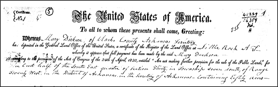
With the new system in place, Clark County pioneers wasted no time in formalizing the ownership of their land. In fact, the very first patent issued by the U.S. General Land Office in Little Rock was to Mary Dickson of Clark County on December 5, 1823, in accordance with the provisions of the Act of Congress of the 24th of April 1820, entitled “An Act making further provision for the sale of the public lands.” Dickson’s eighty acres was the East ½ of the South East ¼ of Section 30 in Township 7 South of Range 20 West.
But Mary Dickson’s “Certificate No. 1” was not the only one issued by the Little Rock Land Office on that December day. She also received No. 2 and No. 3, for additional land in Section 29. Clark Countian Adam Stroud got No. 4, for the East ½ of the Northeast ¼ of Section 28, Township 7 South, Range 20 West. Pioneer Jacob Barkman received Certificates No. 5, 6, 7, 9, 13, 14, 15, 16, 17, and 18. James Stephenson was issued Nos. 11 and 12. Others among the first few certificate holders for Clark County land were Stephen Vaughan (19, 20, 21), Samuel C. Roane (23), William Stroope (24, 31, 33), Thomas Fish (26), John Wilson (27), Nancy Hemphill (28), Samuel Rutherford (29), Jacob Stroope (30), and Abner Hignight (32).
Interestingly, the all-important site of the “initial point” of the survey was pretty much overlooked and ignored until a boundary dispute between Lee and Phillips counties needed to be resolved in the 1920s. Local surveyors re-surveyed the line and found two sweet gum trees utilized for marking by Brown and Robbins over 100 years earlier. Following the discovery, a local chapter of the Daughters of the American Revolution placed a concrete marker there to commemorate the site’s significance in 1926.
Decades later during the bicentennial celebration of the Louisiana Purchase, that “initial point” was surveyed once more, this time using modern technologies such as lasers and GPS. The new investigation showed the 1815 survey that had been completed with very basic equipment in the middle of a swampy wilderness had actually missed the intersection point by less than one inch!
The initial point is now a part of the Louisiana Purchase Historic State Park and the Louisiana Purchase Natural Area at the junction of Lee, Monroe, and Phillips counties. The place claims dual significance today since the Natural Area preserves a portion of the largest remaining headwater swamp in the Lower Mississippi River Valley. The monument was added to the National Register of Historic Places in 1972, and in 1993 the National Park Service designated the site a National Historic Landmark.
