For thousands of years, the land that is now known as Arkansas has been inhabited by native peoples. For much of that time, the Ouachita River valley and much of southwest Arkansas was home to the Caddo Indians and their ancestors. Archeologists are able to glean a great deal of information about Arkansas’s first people by studying the physical evidence of what they left.
Extensive archeological remains exist in the upper Ouachita River valley: almost every field bordering on the river contains evidence of Indian presence in the area. Mounds and campsites all along the Ouachita River and its tributaries attracted archeologists and artifact collectors for years, and early explorations by archeologists uncovered a great deal of pre-historic cultural activity and pottery. One important study completed in late 1939 to early 1940 examined Watermelon Island, also known as Morrison’s Island.
The following information about that study appeared in “A History of Pre-History in the Mid-Ouachita River Valley,” written almost sixty years ago by Hester Davis, who at the time served as Assistant Director of the University of Arkansas Museum. For her complete summary, see The Record (1965), published by the Garland County Historical Society.
Davis reported the following about the Watermelon Island project: “While Arkansas is rich in evidence of aboriginal occupation, funds have only rarely been available for the research required to “read” the story which has been left in the ground—to provide for the excavation and laboratory analysis necessary to any interpretation of prehistory. There are, however, several early bright spots which were made possible by the use of federal grant funds, secured primarily through the efforts of S.C. Dellinger, for forty years the curator of the University of Arkansas Museum. One of these bright spots was the excavation of four large Indian sites along the Ouachita River in 1939 and 1940, two in Hot Spring and two in Garland County.
Early in 1939 Dellinger obtained federal aid through the Works Project Administration (WPA). One immediate impetus to this project was the fact that the Arkansas Power and Light Company was about to construct Blakely Dam, and the resulting reservoir would flood many of the largest Indian sites known along the Ouachita.
“This landmark [Watermelon Island] on the Ouachita River west of Donaldson is probably well-known to many—it certainly was well known to the Indians. At the time of the excavations, there were two mounds on the island, as well as areas where broken pottery and stone tools were found on the surface.
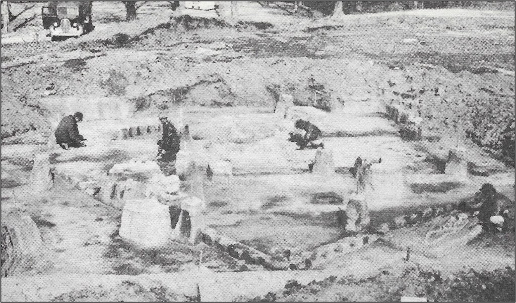
“Several interesting features were uncovered by the Museum’s work. A cemetery area was partially excavated. In a midden area (an area where there is an accumulation and concentration of village refuse and other cultural material), a square house was found and excavated which was approximately 24 feet by 29 feet. The house had been built of upright posts intertwined with reeds of some kind and covered with mud and probably thatch. [The photo by the “U of A Museum” shows workers studying this house, the outline of which can be seen.]
A considerable number of broken pottery sherds were also recovered, as well as a few pieces of stone tools. Some of this broken pottery was thick, had no decoration (which most Caddoan pottery has), and indicated that the original vessels had square, flat bottoms.
“Work ended at this site in February 1940. Soon after that time, Dr. and Mrs. T.L. Hodges [of Hot Spring County] also excavated at the site.”