Life in early twentieth century southeastern Montgomery/northwestern Garland County epitomized upland rural Arkansas; activity in the area seemed quite ordinary. However, one of the region’s most important resources, the Ouachita River, became the reason for the exodus from a large portion of northwestern Garland County. Following Arkansas Power & Light’s completion of Remmel and Carpenter dams on the river near Hot Springs, construction of another similar–but larger–facility at Blakely Mountain loomed on the horizon.
Residents left the area in anticipation of the dam’s construction. By the time the dam actually saw completion, an entire generation had grown up knowing they must leave their homes. As time drew closer for the lake to fill, residents demolished or dismantled buildings in the reservoir area as people moved away.
While citizens endured the closure of area churches and schools, the clearing of the forests, and the relocation of families, they also witnessed the removal of friends and family members from original burial grounds to new locations. Contractors transported remains from the reservoir area to existing cemeteries as well as several sites established for the specific purpose of accommodating graves from the soon-to-be inundated land.
Historic cemeteries in the Ouachita Mountains reflect many rural Arkansas customs. In the nineteenth century, families frequently made their own crude markers, since cost and availability of commercial stones remained out of reach for many. A board, a pile of rocks, or a large, single slab of slate created many “monuments.” Unfortunately, numerous burial sites never bore occupants’ names.
In the 1800s, many people buried their dead in small plots on the family’s own land. The number placed in such small burial grounds peaked in the 1870s and 1880s. With the establishment of a cemetery near the Buckville Baptist Church, more and more citizens interred loved ones there. As the area’s largest cemetery, the number of burials increased from the 1890s through the 1920s; but that trend changed after plans were announced for construction of the new dam. For example, less than one-half the burials occurred in the decade of the 1930s as had taken place in the two preceding ten-year blocks.
In fact, as preparations were made for relocation of graves, officials found one area cemetery that in 1951 “showed no signs of having been used for at least 30 years.” Few wanted to bury a family member in a place that would soon be obliterated.
In late summer and fall of 1951, work on the new dam proceeded and contractors completed the relocation of graves in the Garland County portion of the reservoir area. First, government personnel consulted the next-of-kin of those buried in the area to be inundated, obtaining their views concerning relocation and the selection of new sites.
Prior to the removal of remains, contractors gathered releases from relatives of persons known to be buried in soon-to-be-inundated locations. However, officials never determined the exact number of burials in area cemeteries; many older graves were unmarked. Locating family members of all those interred proved impossible, and a court order became necessary for legal authorization to relocate the cemeteries. Specifically, a petition filed by the government in federal district court gave authorities permission to “dis-inter, remove and re-inter all bodies found in cemeteries located within the area.” The Arkansas State Board of Health also granted a “Disinterment Permit” as a part of the process, granting “the United States of America or its Contractor” the right to “disinter and remove all dead human bodies” from within area cemeteries.
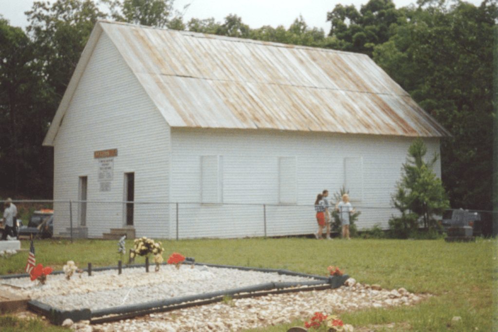
Contractors completed the relocation of some 1,200 graves in Garland County cemeteries in September of 1951; they moved Montgomery County graves the following summer. New cemeteries were built in various places in Garland County for re-interment of the dead not taken to existing burial grounds–among them the New Mount Pleasant near Mountain Valley, and new cemeteries (New Cedar Glades, Bradley, Pittman-Williamson, Brooks) at the top of the hill near the existing Buckville Cemetery. The Buckville Cemetery remains at its original site today, just above water level on the northern shore of Lake Ouachita. The church now sits between the Buckville Cemetery and the cemeteries on the hill which were moved there by the Corps of Engineers. The Buckville Cemetery was added to the National Register of Historic Place in 2007 for its significance as the last remnant of the Buckville community still in its original location.
The removal of graves from the cemeteries in the Garland County reservoir area took about three months. Author Shirley Abbott (a descendant of those dislocated by the dam construction) described the cemetery relocation work this way: “But before the sluice gates were closed, these same men went from one burying ground to another, prying up the stones, disinterring the rotting coffins, and laying them ceremoniously to rest on higher ground . . . They saved what they could.” Workers “boxed” remains, then transported them in a “covered vehicle to their new resting places.” Acidic soils, considerable vegetation in the cemeteries, and bodies’ conditions when buried, all contributed to rapid deterioration and decomposition. This meant that little or nothing existed in graves more than twenty or thirty years old. Workers dug four or five feet deep searching for any traces of bodies. If no remains were found, dirt was then “taken out and boxed for removal” to new locations. Interestingly, few people visited the cemeteries during the relocation process. According to officials, “those who come to the cemeteries just look around and leave.”