Most who enjoy the recreational benefits of Lake Ouachita seldom consider the lives that changed forever as a result of Blakely Mountain Dam’s construction. Life in what once existed as an ordinary rural Arkansas region transformed into an extraordinary experience for those who lived there: The completion of three dams on the upper portion of the Ouachita River meant that the area would never be the same.
As American pioneers arrived in Arkansas during the nineteenth century, many small, isolated, self-sufficient farmsteads with widely dispersed rural neighborhoods and hamlets existed in the Ouachita Mountains backcountry. Concentrations of residents established Buckville and Cedar Glades as major communities in the sparsely settled Ouachita Mountains in the latter portion of the 1800s. As in the rest of Arkansas, people built homes, churches, schools, and businesses, and spent their spare time involved in activities such as town baseball teams and fraternal organizations. Life in the region typified rural uplands Arkansas.
Agriculture dominated the upper Ouachita River valley’s economy well into the twentieth century. Farmers produced much of their own food, including home-cured meats, chickens, eggs, milk, butter, sorghum, fruits, and vegetables. Cotton, corn, cattle, and chickens provided income. By 1920 few steps toward modernization had occurred in northwestern Garland County. Living conditions in the mountains remained relatively primitive. Paved roads and basic services common to modern urban society never arrived. But a complete transformation loomed on the horizon.
Government officials had investigated the possibilities surrounding the construction of dams on the Ouachita River as early as the 1890s, but their studies produced no real efforts to improve the stream, either for navigation or flood control. However, entrepreneur Harvey Couch envisioned power production on the river and made plans to harness the Ouachita. Couch’s company, Arkansas Power & Light, built two dams near Hot Springs (Carpenter and Remmel), and planned a third in the vicinity of Blakely Mountain. During the 1920s and 1930s the company purchased thousands of acres of land in the projected reservoir area. Residents speculated about the reservoir’s potential water level and slowly left the area in anticipation of the dam’s construction, dreading the day when their homes would no longer exist.
However, Arkansas Power & Light never constructed the new facility. The federal government took on the project and built the dam under the auspices of the Vicksburg District of the Army Corps of Engineers. The government bought farm after farm until it acquired the entire reservoir area although relatively little land remained for the government to purchase. By this time, private citizens owned only a few small parcels in the entire area. Of the approximately 77,000 acres ultimately included in the dam and reservoir project, Arkansas Power & Light controlled about 44,000, and 22,000 already belonged to the Ouachita National Forest.
As construction on the dam progressed, families sold their property and moved away, even though some waited until the last possible moment to leave. A small contingent of residents remained in the area by leasing from the government, clinging to their land until the reservoir began to fill.
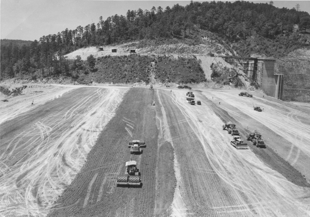
By 1947 almost all of the area’s buildings had been torn down. Post offices closed: the last delivery to an office within the reservoir area occurred in 1953. Membership in organizations declined and the groups either disbanded or moved to other locations. School enrollment declined. Churches closed or moved. Workers cut down forests and stripped land of underbrush.
While residents observed the closure of area churches and schools, the clearing of the forests, and the relocation of families, they also witnessed the removal of friends and family members from original burial grounds to new locations. Contractors transported remains from the reservoir area to existing cemeteries as well as several sites established for the specific purpose of accommodating graves from the soon-to-be inundated land. Today, only the Buckville Baptist Church and Cemetery remain as tangible reminders of the former communities. The cemetery has been added to the National Register of Historic Places because of its significance as the last remnant of the Buckville community still in its original location.
Blakely Mountain Dam was officially dedicated July 4, 1956. By the time of the dam’s completion, an entire generation had grown up knowing thousands of acres would be obliterated. Ancestors of the dispossessed homesteaded the region, cleared the land, built homes, raised families, buried the dead, and formed life-long friendships in this place. After selling their land, dislocated residents looked on as the forests were cut down; they saw their homes, schools, churches, and businesses town down; and they watched as workers carried the remains of friends and relatives away from local burial places. Finally, they saw the water permanently flood their land.
Lives changed forever as a result of Lake Ouachita’s construction. Indeed, the dispossessed were forced to sell, leave their farms, and relocate—to uproot themselves from communities where their families had lived for generations. It was at the expense of these people that the federal government produced long-term benefits for the entire Ouachita River Valley in terms of power production, recreation, and flood control. Ironically, Blakley Dam aimed to prevent flooding downstream, but actually placed thousands of acres permanently under water in the form of Lake Ouachita. One observer described the phenomenon this way: “A river and a road linked the two little Garland county communities of Buckville and Cedar Glades in life. A great lake now unites them in death. For, Buckville and Cedar Glades are gone. Their executioner–progress.”