With hurricane season underway, many coastal locations must brace for damaging winds, storms, and heavy rains. Such storms’ biggest threat to Arkansas is flooding, and a major overflow which occurred over ninety years ago illustrates the potential impact of such an event. While not the result of a hurricane, that flood–arguably the nation’s greatest natural disaster–wreaked havoc on Arkansas and the entire Mississippi River valley.
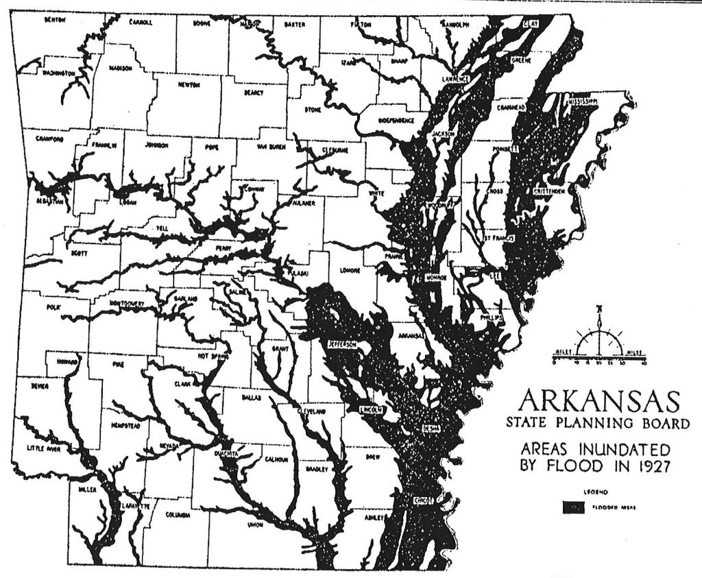
The Flood of 1927 brought tremendous destruction to the region, taking hundreds of lives and inundating over sixteen million acres of land. Water covered more than 13 percent of the state of Arkansas, damaging approximately 162,000 homes. About 700,000 people were displaced as water inundated the land to depths of up to thirty feet. While damage in the Ouachita River valley did not rival that of locations in Arkansas’s Delta, this area did indeed feel the effects of the high waters.
The great flood of 1927 actually began in 1926. Heavy rains in Arkansas, Oklahoma, and northern Louisiana during December 1926 resulted in the filling of the Arkansas and Red rivers to capacity. By February of 1927, most all area rivers were near flood stage. Then, in March, heavy rains continued across the entire mid-Mississippi River drainage system. In April, torrential rains in Arkansas brought record floods to most streams, including the Ouachita River. The month’s rainfall total was among one of the heaviest one-month amounts ever recorded in the area.
With the heavy rains, came reports of overflows. A stage of 20 feet at Arkadelphia was predicted on April 14 as the Ouachita’s tributaries grew “out of their banks.” The Caddo River was expected to be over the highway between Arkadelphia and Hot Springs by the morning of April 15, when the Ouachita stood at 21.7 feet. Travel between Malvern and Arkadelphia was blocked by several feet of water over the highway. The rainfall total at Malvern for April 15 reached 3.1 inches. The water continued to rise, and by noon, predictions of 22.5 to 23.2 feet downstream at Arkadelphia would make this overflow a record.
Reports of delayed agricultural activity and soil erosion were common. But just as it seemed conditions would improve, one source reported that “a cloudburst in the Benton section last night [April 19] washed out half a mile of the roadbed of both the Missouri Pacific and Rock Island railroads.” This not only interrupted rail service, but also mail and telephone service, since telephone poles had been washed away as well. Malvern received 2.63 inches of rain on April 20, and 3.52 on April 21, and the Ouachita rose even more before the waters began to recede. Water level climbed at Donaldson, and, according to one report, Donaldson was “under water for the first time in history.” By April 21, an area paper observed that “the floods are the severest in the history of Arkansas. The Ouachita River at Arkadelphia has set a new record, and is still rising.”
The situation at Arkadelphia was significant to Malvern, for flood conditions caused fears that electrical power would be lost. The flood stage of 23.9 there was just nine inches short of reaching Arkansas Power & Light’s transformer plant in Arkadelphia. If the water had reached the plant, current would have been turned off at Malvern, and Arkadelphia plunged into darkness.
While damage in the upper Ouachita River valley from the Flood of 1927 did not rival that of locations in Arkansas’s Delta region, the high water served as a reminder of how extreme weather conditions can result in disaster. Frequent flooding continued to plague low sites along the river until the construction of three dams on the upper Ouachita River (Remmel, Carpenter, and Blakely) helped lessen the problem by the latter half of the twentieth century.